BY BILL KNIGHT
Flooding is more frequent and more costly, and destruction like what Peoria County endured four years ago this spring might be considered bad luck. Homeowners, developers and government couldn’t foresee such dangers.
Except: Maybe they could.
Storms happen more often and are more severe, and rising water will increase areas of higher risk for flooding by 45 percent by the year 2100, according to the Federal Emergency Management Agency (FEMA), almost doubling flood-pone properties – land covered by the National Flood Insurance Program, the 45-year-old system helping losses there. The “100-year flood” is expected to occur every 3 to 20 years, scientists say.
Indeed, the number of declarations of major disasters has shot up five-fold in the last 30 years, according to FEMA, from a median (midpoint) of 103 annually in the last 30 years compared to a median of 24 in the previous three decades. There were 103 last year and 26 already through mid-April 2017.

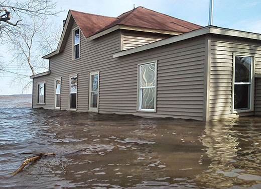
Photo submitted by Joe Clevenger showing the 2013 flood engulfing his home south of Chillicothe.
Storms that swept through the Midwest in March cost insurance companies about $1.7 billion, with Illinois alone costing insurers about $300 million between January and April, according to Aon Benfield, a reinsurance firm, and $225 million of that was between Feb. 28 and March 2 due to severe weather, the type that authorities say is becoming the rule rather than the exception.
Back in 2013, about 300 Peoria County homes were flooded, causing $2.5 million in losses (in structures and contents), according to Peoria County’s former head of Planning and Zoning Matt Wahl, who adds, “Approximately 500 homes were impacted by the 2013 flooding.
“The County was awarded two Hazard Mitigation Grant Program grants totaling $3,086,438 for the acquisition/demolition of 40 flood-impacted properties along the Illinois River (Rome) and Kickapoo Creek (Edwards),” he continues. “The funding comes from FEMA. We are in the process of completing this project in summer 2017 and expect to acquire 30-plus properties from the original list.
“To date, 11 properties have been elevated following the 2013 flood,” he continues. “These projects were funded privately by the property owners, with some supplemental funding coming from the National Flood Insurance Program’s ‘Increased Cost of Compliance’ funding (up to $30,000).”
Ten years ago, the Peoria-area Tri-County Regional Planning Commission set some responsibility for flood problems at the feet of elected officials, but was optimistic.
“Political willpower” is key, the TCRPC said. “It is expected that the current and future political climates are favorable for supporting and advancing future hazard mitigation strategies.”
Wahl prefers that approach.
“You cannot predict the weather, but you can be prepared for it,” he says. “Through development of Hazard Mitigation Plans and community-outreach programs, we can better prepare our residents for unpredictable scenarios. Peoria County has reduced the amount of future flood losses through the acquisition of 118 properties in floodplain areas since the late 1980s, as well as the elevation of approximately 50 flood-prone structures. As a result, the disruption of services and the amount of flood loss has been substantially reduced, to the extent where the flooding in 2015 and 2016 had an impact only on a few dozen properties, rather than hundreds. If we can continue to implement programs and voluntarily work with property owners, insurance, politics and climate change won’t have very much impact on the floodplains of Peoria County.”
Still, about 90 percent of U.S. disasters are floods, according to the National Flood Insurance Program (NFIP), and Joseph Davis of the Society of Environmental Journalists says extreme weather is behind the accelerating crisis.
“Climate is making sea-level rise and storm surge part of the story,” he writes.
That’s also a national security issue, according to some military leaders.
Speaking to an American Security Project conference at the University of Pittsburgh in February, Rear Admiral Dr. David Titley (USN) described three tenets of why climate change must be on policymakers’ agenda: “It’s all about people, it’s not polar bears,” he said. “It’s about water – too much, too little, wrong place, wrong time – and, finally, it’s about the change.”
The 2013 flood in Peoria County was overwhelming.

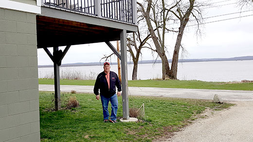
Joe Clevenger walks around his house South of Chillicothe. Following the 2013 flood that inundated his house, Clevenger had the structure elevated.
“The disaster was of such severity and magnitude that effective response and recovery was beyond state and local capabilities,” said IEMA director Jonathan Monken.
In Edwards, Connie Downard runs Edwards Tap on Powdermill Road a few feet from Ill. Route 8. She reflects on being inundated in 2013.
“Years ago a lot of people helped us,” she says. “We had so many people – more than two dozen at a time – help us clean up and bring in big fans to dry out. We were only closed two weeks. We’re ready for anything.”
Anything except government bureaucracy, that is.
“It was mostly a bunch of BS,” she says. “It floods all the time here. We sure weren’t going to put it up on stilts.”
Andrew Braun, Peoria County’s current floodplains expert, explains, “She was issued a floodplain development permit, which allowed for repairs. The structure was not determined to be substantially damaged and therefore was not subject to any enforcement action.
“Structures which had received damages or have made improvements equal to or greater than 50 percent of the assessed market value must be mitigated,” Braun continues, “by elevation, relocation or demolition. Failure to comply will result in enforcement action against a property owner.”
Along the Illinois River, Chillicothe-area residents withstood considerable flooding then.
“A 27-foot flood was OK, but that was over 29 feet,” says Joe Clevenger, whose home is in Rome.
That year, the Illinois River – whose flood stage is 18 feet – rose to 29.35 feet, a record, according to the U.S. Army Corps of Engineers. (Its high-water mark in 2015 was 27.09 feet on June 30, and last year 26.49 feet Jan. 3.)
“Ours is a 100-year-old house we’ve lived in about 20 years,” Clevenger says. “The 2013 flood was our third, and worst.
“FEMA provided $30,000 to elevate our house,” he continues, “and it cost $38,000. Some neighbors chose demolition and took a loss because what was offered [to help] was nowhere near Fair Market Value. Some were condemned.
“We didn’t have a basement, just a crawl space, but [County] zoning required we even tear out the footings,” he adds. “So we ended up with a pile of concrete about 15 feet high out front.”
Besides private insurance, the NFIP pays out claims, but disaster funding isn’t in the federal budget. Such relief is considered “emergency spending,” while preparednesss is chronically underfunded. So the government spends billions afterward but little beforehand. The Government Accounting Office says the NFIP is about $24 billion in debt, which led to the Homeowner Floods Insurance Affordability Act of 2014, seeking to phase out subsidized flood insurance for more than a million people by raising premiums some 10 percent and encouraging elevating structures in flood-prone areas.
“Our flood insurance [premium] was about $1,500,” Clevenger says. “Now it’s $200. There’s not much risk if we’re up in the air.”
Even with elevation, homes can lose power and be cut off by flooded roads blocking emergency services and access to food, fresh water, etc. But Clevenger isn’t worried.
“We have a well and a generator, so even if Chillicothe is underwater, I’ll be ‘lights on’ here,” he says.

Recent Comments