

MIKE MILLER
Monday Aug. 10 started off as a sunny, clear day with a slight chance of rain in the afternoon in Central Illinois. I happened to be at our Tawny Oaks facility, when around 2:30 p.m. the sky to the west became an odd shade of brown. It looked like a dust-storm was heading our way. The winds came and hit from the west and just didn’t give up. I grabbed my Kestrel handheld wind meter and went out like a fool to see how strong the gusts were. The highest gust I recorded was 52 mph. This was not the usual wind ahead of your normal summer squall line. It was a Derecho.
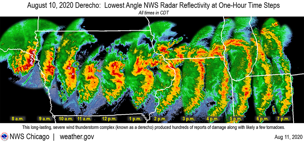
The word Derecho (pronounced “dey-RAY-cho”) was first coined in 1888 by Dr. Gustavus Hinrichs, a professor of physics at the University of Iowa. It is a Spanish word that means direct or straight ahead. He used it to described the straight-line winds that are a hallmark of this weather phenomenon. Since then, the National Weather Service has intermittently used the term as a storm designation. Since 1987, it has been used more regularly to describe these fast-moving and strong wind events. This storm started in western Iowa and rampaged through Illinois into Indiana. Along the way, it produced numerous tornadoes and registered over 700 instances of winds over 57 mph at official National Weather Service stations. Many wind reports were in the 75-100 mph range. All of this took place in the period of around 11 hours across a 700-mile-long path through the Midwest.
The damage was widespread and severe. In Iowa, it is estimated that 43% of the state’s corn and soybean crops, over 10 million acres, were destroyed. The crop destruction was so massive that it showed up on satellite images. Power outages have lasted for days. City officials in Cedar Rapids, Iowa, estimate that the damage toll and aftermath of the Aug. 10 Derecho is greater than the 2008 and 2016 floods. Those events brought FEMA and government officials to the city to aid in recovery. So far, this storm event has largely been ignored by federal agencies.
Locally, the central Illinois region also saw widespread damage. Trees throughout the region were uprooted, power outages were widely reported, and structural damage was evident. We seemed to miss the more severe effects that parts of Iowa experienced. The energy of the storm was much more concentrated to the west. By the time it reached us, the storm had expanded and the energy was dispersed over a broader storm front, with the most severe concentrations of storms to the north of us.
Any storm squall line moving through the Midwest has the potential to form into these super-storms. Luckily, most move through without developing into these severe events. This wasn’t the first Derecho to hit us. On June 30-July 1, 2014, we were hit by a “one-two punch” where two Derecho events went through Central Illinois in a single day. This won’t be the last one we see either. Keep your eyes to the skies, and your weather radio tuned in during the summer months. There’s never a dull moment in the Midwest.